Geographical features
The rocks covering the Division form part of the oldest formations and are referred to as the Archaens. Very little is known as regarding the order of super imposition of the Archasean rocks. The sehistese and phyletie rocks covering the northern west part of the Division are the oldest and were of large pile of sediments in a geosynolise which were felled up and metamorphosed and later up lifted into large mountains. During the period, the major portion of granite were intruded. Repeated period of volcanic activity during the Archern time give rise to numerous basic igneous rocks, the most prominant of which are the Dalma lavas along the northern border of the division.The predominant rocks in the area of Seraikela and Kharsawan Ranges are granites with numerous intrusions of dolerite. The granite is known as the “Singhbhum granite” and is of alkaline type with accessional out crop ot feldspar. Unmetamorphosed shales and phyllites are found in the northern areas. Other rocks of lesser importance and incidence are epidiorites, schists with quarts veins, sand stones and conglomerates. An extensive area presently under forest cover, particularly hills and hill slopes do not contain soil of any description. On account of severity of erosion, most of it is completely lost, exposing rocks and boulders all over. Vegetation and the growth are sustained by soil available in pockets and crevices. Soil is often found mixed with boulders and pebbles. Strait of murum appear at varying depth of top soil. The soil is loam,sandy loam,clayey loam and at places clay.On account of high incidence of grazing and fire the soil in the plain forests in particular, is compact having very low infiltration capability. This causes high run off leading to the formation of ravines and gulfs. The fertility is very low. Nutrient contents and water holding capacity are miserably poor. In brief it may be said that the soil in the forests of Seraikela Forest Division is highly refractory and is in-hospitable to natural tree growth.
Climate and rainfall
The climate is monsoon type characterized by three main seasons an intensely hot and dry summer season from the middle of February to the end of May,a warm and humid rainy season from mid June to the beginning of October and a mildly cold season from November to end of January. October is the linking month between the rains and winter.The heat in summer months is intensified by radiation from the rocky hill slopes that become bare through leaf-fall. The maximum temperature recorded is as high as 1150 F and the diurnal range of temperature is between 200 F. to 400 F. Loo – the hot westerly wind causes desiccation and there are occasional cases of sun stroke in the locality. On the whole, the forest does mitigate the severity of heat and it is never unhealthy in the forest areas. The main characteristic feature of summer is that the temperature is kept down by occasional showers and often preceded by cyclonic wind. These thunder showers are particularly beneficial to sal forests because this rain help in germination of Sal seed. The average annual rainfall of Seraikela district in the last 10 year recorded is as low as 566 mm in 2010 and the highest recorded was 1511.7 mm in 2007. From the above table it is clear that June, July, August and September are the main rainy months with maximum days with rain . October and in some year November reported with some rain days. These October rain popularly known as Hathia has significance for weeding and hoeing in plantation.
Tourist Attractions
Chandil Dam – Chandil Dam standing on the Subarnarekha River is a place of scenic beauty. This dam is one of the most visited places of jharkhand. The museum located close to the Chandil dam has scripts written on rocks, which are 2000 years old. The multi-purpose Chandil dam was built across the meeting place of both the rivers. The dam is 220 meter in height and the height of its water level is 190 meter from different places tourists coming from different parts of the country enjoy boating and the natural beauty in and around the dam. Chandil is famous for its importance in the field of tourism. The River Swarnarekha flows through this region. The Karkori River originating from the Hundru falls mingles with the Swarnarekha River here at chandil.
Akarshani Temple - Every year on the eve of Akhan Jatra i.e., beginning of magh mas of hindu panchang, Akarshini Mela is organized at Mata Akarshini Mandir situated in Kharsawan of Saraikela Kharsawan district of Jharkhand. The famous temple of Mata Akarshini Mandir is situated at the height of 320 Feet on the top of hill. People from nearby districts and also from Orrisa and Bengal come to participate in this fair. This fair includes Swing rides, Meena Bazar, Food Stalls and Local shopping stalls etc.
Jayda Temple - An Ancient Temple of Lord Shiva, one of the pilgrimage of Jharkhand. Situated on the way to Ranchi-Tata and Shore of Swarnarekha river. A Fair held every year on the eve of Makar Sankranti(Tusu Festival).
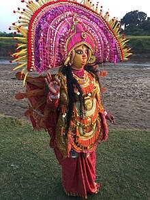
Chhau Dance - Chhau dance, also spelled Chhou dance, is a semi classical Indian dance with martial and folk traditions. It is found in three styles named after the location where they are performed, i.e. the Purulia Chhau of West Bengal, the Seraikella Chhau of Jharkhand and the Mayurbhanj Chhau of Odisha. The dance ranges from celebrating martial arts, acrobatics and athletics performed in festive themes of a folk dance, to a structured dance with religious themes found in Shaivism, Shaktism and Vaishnavism. The costumes vary between the styles, with Purulia and Serakeilla using masks to identify the character. The stories enacted by Chhau dancers include those from the Hindu epics the Ramayana and the Mahabharata, the Puranas and other Indian literature. The dance is traditionally an all males troupe, regionally celebrated particularly during spring every year, and may be a syncretic dance form that emerged from a fusion of classical Hindu dances and the traditions of ancient regional tribes.The dance is amazing and brings together people from diverse socio-economic backgrounds in a festive and religious spirit.
Forest Rest House
- Raghunathpur Rest House
- Kandra Rest House
- Kharsawan Rest House
| Range, Beat and Sub-Beat of Saraikela Division |
| Range Name |
Beat Name |
S.No. |
Sub-Beat Name |
| Chandil |
Chandil |
1 |
Bareda |
| 2 |
Chandil |
| 3 |
Kadla |
| 4 |
Makula |
| 5 |
Ramnagar |
| 6 |
Saharbera |
| Khunti |
1 |
Bansa |
| 2 |
Barsira |
| 3 |
Khunti |
| 4 |
Lapaibera |
| 5 |
Urmal |
| Patkum |
1 |
Kalyanpur |
| 2 |
Kutam |
| 3 |
Lawa |
| 4 |
Patkum |
| 5 |
Royadih |
| 6 |
Sirum |
| Ramgarh |
1 |
Tamilia |
| Kharsawan |
Huranda |
1 |
Doro |
| 2 |
Kondadih North |
| 3 |
Kondadih South |
| 4 |
Lakhandih |
| 5 |
Raidih |
| 6 |
Raijama North |
| 7 |
Raijama South |
| 8 |
Raisindri North |
| 9 |
Raisindri South |
| 10 |
Silpingda |
| Jojohatu |
1 |
Baruhatu |
| 2 |
Gomeadih |
| 3 |
Jomro |
| 4 |
Meramjanga |
| 5 |
Mutugora |
| 6 |
Rugudih |
| Kuchai |
1 |
Bandi |
| 2 |
Bayang |
| 3 |
Dango |
| 4 |
Kharsawan |
| 5 |
Puniburi |
| 6 |
Regadih |
| 7 |
Sarubera |
| Saraikela |
Gamharia |
1 |
Adityapur |
| 2 |
Kalikapur |
| 3 |
Kandra |
| 4 |
Murgaghutu |
| 5 |
Parwatipur |
| 6 |
Rajpur |
| 7 |
Sanpara |
| 8 |
Sirdharpur |
| 9 |
Udaipur |
| Mohitpur |
1 |
Barjudih |
| 2 |
Hatnada |
| 3 |
Huddoo |
| 4 |
Shantipur |
| 5 |
Sini |
| Rajnagar |
1 |
Betkal |
| 2 |
Bisrampur |
| 3 |
Chakradharpur |
| 4 |
Chauradih |
| 5 |
Chorbandha |
| 6 |
Rola |
| Saraikela |
1 |
Nilmohanpur |
| 2 |
Paharpur |
| 3 |
Rangamatia |